Catchment concepts
This page explains the fundamental concepts behind catchment delineation in earthkit-hydro.
What is a catchment?
A catchment (also called a watershed or drainage basin) is the area of land where all water flows to a single outlet point. Understanding catchments is fundamental to hydrological analysis because they define the spatial extent of water movement in a landscape.
When rain falls within a catchment, it eventually flows to the catchment outlet, either as surface runoff or through subsurface pathways. This makes catchments natural units for studying water balance, flood routing, and water resource management.
How catchment delineation works
In earthkit-hydro, catchment delineation works by tracing flow paths upstream from specified outlet locations. The process:
Specify outlet locations - Define one or more points where you want to delineate catchments
Trace upstream - Follow flow directions backwards to identify all cells that drain to each outlet
Label cells - Assign each cell a label corresponding to its outlet, with labels being 0, …, number of points - 1
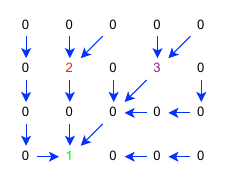
Animation showing catchment delineation from multiple outlets. Cells are progressively labeled as the algorithm traces upstream from outlet points.
Overlapping catchments
When multiple outlet points are specified, their catchments may overlap (i.e., one outlet is upstream of another). By default, earthkit-hydro resolves this by giving priority to the most downstream outlet.
This behavior means:
Upstream catchments are absorbed into downstream ones
Only non-overlapping catchment portions remain labeled for upstream points
The result shows distinct catchment boundaries
This default is useful when you want to identify major basin boundaries without double-counting areas.
Subcatchments
Sometimes you want to preserve boundaries for all specified outlets, even when they overlap. Setting overwrite=False enables subcatchment delineation:

Animation showing subcatchment delineation where each outlet retains its full upstream area, even when catchments overlap.
This mode is useful for:
Identifying contributing areas to specific monitoring stations
Analyzing nested catchments at different scales
Understanding how upstream changes affect downstream locations
Practical considerations
Choice of outlets: Where you place outlet points significantly affects results. Common choices include:
River gauging stations for calibration
River mouths for full basin analysis
Confluences for tributary analysis
Points of interest like water intakes or discharge locations
Coordinate systems: Ensure your outlet locations correspond to the location on the river network to avoid misalignment.
Resolution effects: Catchment boundaries depend on the resolution of your river network.
See also
Catchment delineation - Practical guide to delineating catchments
Specifying locations - How to specify outlet locations correctly
River network concepts - Understanding river network representation